1State Key Laboratory of Information Engineering in Surveying,Mapping and Remote Sensing,Wuhan University, Wuhan 430079, China 2Zhejiang Academy of Surveying & Mapping, Hangzhou 311100, China 3Faculty of Resources and Environmental Science, Hubei University, Wuhan 430062, China 4Key Laboratory of Regional Development and Environmental Response, Hubei University, Wuhan 430062, China 5Collaborative Innovation Center of Geospatial Technology, Wuhan 430079, China
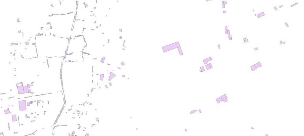
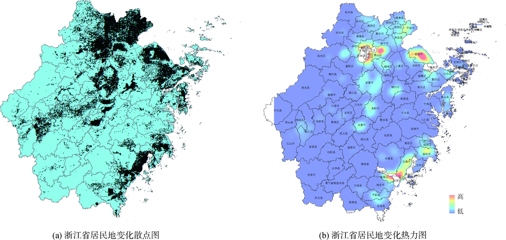
[Objective] This paper aims to identify the changes of geographic elements in surveying and mapping, as well as their driving mechanism.[Methods] We collected the changes of residential areas from Zhejiang Province. With the help of GIS overlay and correlation analysis, we analyzed the socio-economic driving forces behind these changes.[Results] We found that the changes were concentrated in the north, central and southeast parts of Zhejiang Province.The development of industry was the main positive driving force (correlation coefficient: 0.336).The development of the service or retail sectors and government public investments were negative driving forces for the changes (correlation coefficients: -0.054 and -0.100).[Limitations] The accuracy of statistical data needs to be further improved to reduce the “false changes” from cartographic synthesis.[Conclusions] The changes in residential areas were different and their economic driving factors were also different.
周衡,陈张建,李爱勤,成晓强,吴华意. 居民地变化的空间分布及社会经济驱动力分析——以浙江省为例*[J]. 数据分析与知识发现, 2020, 4(9): 81-90.
Zhou Heng,Chen Zhangjian,Li Aiqin,Cheng Xiaoqiang,Wu Huayi. Spatial Distribution and Socio-economic Driving Forces of Residential Changes: Case Study of Zhejiang Province. Data Analysis and Knowledge Discovery, 2020, 4(9): 81-90.
( Li Deren, Miao Qianjun, Shao Zhenfeng. Orientation and Framework of Geo-informatization System[J]. Geomatics and Information Science of Wuhan University, 2007,32(3):189-192, 196.)
[2]
刘文谷. 测绘行业改革模式研究[D]. 重庆: 重庆大学, 2003.
[2]
( Liu Wengu. Research on Reforming Model of S/M Industry[D]. Chongqing: Chongqing University, 2003.)
[3]
张继贤, 顾海燕. 关于新型测绘的探索[J]. 测绘科学, 2016,41(2):3-10.
[3]
( Zhang Jixian, Gu Haiyan. The Exploration of New Surveying and Mapping[J]. Science of Surveying and Mapping, 2016,41(2):3-10.)
( Wu Zhangfeng, Liu Yining. Research on Methods for Detecting Change in Urban Spatial Information[J]. Shanghai Land & Resources, 2016,37(4):89-91, 95.)
( Chen Jiaquan, Chen Xueyang, Yin Ming. Talking about Development Direction of Geographical Information Science and Technology under the Background of Natural Resource[J]. Geospatial Information, 2019,17(9):18-21.)
( Xiao Jianhua, Peng Qingshan, Li Haiting. “Geomatics 4.0”: Surveying, Mapping and Geoinformation in the Internet Era[J]. Bulletin of Surveying and Mapping, 2015(7):1-4.)
doi: 10.13474/j.cnki.11-2246.2015.0198
( Ning Jinsheng, Wang Zhengtao. The Newest Progress of Surveying & Mapping Oriented Informatization Stage[J]. Science of Surveying and Mapping, 2010,35(5):5-10.)
[8]
张效康. 地理国情监测数据可靠性分析与控制方法研究[D]. 武汉: 武汉大学, 2017.
[8]
( Zhang Xiaokang. Reliability Analysis and Controlling Methods for National Geographic State Monitoring Data[D]. Wuhan: Wuhan University, 2017.)
( Li Xinbin, Jiang Na, Kong Jie. A Change Detection Method of Polygon Features Based on Geometrical Characteristic[J]. Geomatics & Spatial Information Technology, 2011,34(3):177-180.)
( Dai Hailun, Wang Dedong, Liu Zhongqiu, et al. An Incremental Updating Method Research for Updating Basic Geographic Information Data Based on the Geographic National Condition Census Data[J]. Geomatics World, 2017,24(3):92-96.)
( Wang Shu, Ji Leijing, Zhang Xueying, et al. Change Detection of Geographic Features Based on Web Pages[J]. Journal of Geo-information Science, 2013,15(5):625-634.)
doi: 10.3724/SP.J.1047.2013.00625
[13]
吉雷静. 面向网页文本的地理信息变化语义检测方法研究[D]. 南京: 南京师范大学, 2013.
[13]
( Ji Leijing. Semantic Change Detection of Geographic Information Based on Web Pages[D]. Nanjing: Nanjing Normal University, 2013.)
( Wang Zihao, Duan Jia, Zhang Yi. A Method to Detect Changes of Geographic Elements by Using Topological Relation[J]. Surveying and Mapping, 2015,38(1):14-16.)
( Yang Cunjian, Zhou Chenghu. Extracting Residential Areas on the TM Imagery[J]. Journal of Remote Sensing, 2000,4(2):146-150, 166.)
doi: 10.11834/jrs.20000212
( Mu Fengyun, Zhang Zengxiang, Chi Yaobin, et al. Dynamic Monitoring of Built-up Area in Beijing During 1973-2005 Based on Multi-original Remote Sensed Images[J]. Journal of Remote Sensing, 2007,11(2):257-268.)
doi: 10.11834/jrs.20070236
( Gong Lifang, Li Aiqin, Chen Zhangjian. Case Study of Geospatial Big Data Driven by Government Application[J]. Bulletin of Surveying and Mapping, 2019(8):125-129.)
( Peng Rui, Xu Dalu, Zhu Xuejian. Research and Production Application on the Incremental Update Technology of Zhejiang Provincial Fundamental Geospacial Database[J]. Geomatics & Spatial Information Technology, 2018,41(10):104-107.)
[19]
Cliff A D, Ord J K. Spatial Processes: Models and Applications[J]. Population, 1982,37:963.
[20]
Anselin L, Kelejian H H. Testing for Spatial Error Autocorrelation in the Presence of Endogenous Regressors[J]. International Regional Science Review, 1997,20(1/2):153-182.
doi: 10.1177/016001769702000109
[21]
Wang S J, Fang C L, Wang Y. Spatiotemporal Variations of Energy-related CO2 Emissions in China and Its Influencing Factors: An Empirical Analysis Based on Provincial Panel Data[J]. Renewable and Sustainable Energy Reviews, 2016,55:505-515.
doi: 10.1016/j.rser.2015.10.140
( Meng Jie, Wang Huiwen. Logcontrast PLS Path Modeling of Multiple Compositional Data[J]. Application of Statistics and Management, 2009,28(3):436-442.)
[23]
Zhang Y, Li C H, Wang T W, et al. County-level Patterns of Cropland and Their Relationships with Socio-economic Factors in Northwestern China[J]. Agriculture, Ecosystems and Environment, 2014,203(1):11-18.
doi: 10.1016/j.agee.2014.11.016
( Wang Xinsheng, Liu Jiyuan, Zhuang Dafang, et al. Spatial-temporal Changes of Urban Spatial Morphology in China[J]. Acta Geographica Sinica, 2005,60(3):392-400.)
doi: 10.11821/xb200503005
( Liu Jiyuan, Wang Xinsheng, Zhuang Dafang, et al. Application of Convex Hull in Identifying the Types of Urban Land Expansion[J]. Acta Geographica Sinica, 2003,58(6):885-892.)
doi: 10.11821/xb200306012
( Wang Xueqing, Chen Yuan, Liu Bingsheng. Exploratory Spatial Data Analysis about the Development Level of the Regional Real Estate Economy China—The Research Based on Global Moran’s I, Moran Scatter Plots and LISA Cluster Map[J]. Journal of Applied Statistics and Management, 2014,33(1):59-71.)
( Yang Qingqing, Chen Jia, Li Bohua, et al. Evolution and Driving Force Detection of Urban Human Settlement Environment at Urban Agglomeration in the Middle Reaches of the Yangtze River[J]. Scientia Geographica Sinica, 2018,38(2):195-205.)
doi: 10.13249/j.cnki.sgs.2018.02.005
( Gu Liuyang, Zhang Yongfu, Zhu Xiaoqiang, et al. Simulation of Land Use Landscape Pattern Prediction and Analysis of Driving Forces Based on Remote Sensing and CA-Markov Model[J]. Journal of Engineering of Heilongjiang University, 2017,8(2):14-20, 30.)
( Song Jinping, Zhao Xijun, Wang Qian. Analysis of Land Use Change and Socioeconomic Driving Forces of Fengtai District in Beijing[J]. China Population Resources and Environment, 2008,18(2):171-175.)
( Ye Ying, Chen Chongguo, Lin Xi. Theory and Application of Partial Least Squares Regression[J]. Strait Journal of Preventive Medicine, 2005,11(3):3-6.)