Assessing Data Integrity of OpenStreetMap Based on Night Lights
Fei Liu1,Xiaoqiang Cheng2,4(),Huayi Wu1,3
1 State Key Laboratory of Information Engineering in Surveying, Mapping and Remote Sensing, Wuhan University, Wuhan 430079, China 2 Faculty of Resources and Environmental Science, Hubei University, Wuhan 430062, China 3 Collaborative Innovation Center of Geospatial Technology, Wuhan 430079, China 4 Key Laboratory of Regional Development and Environmental Response, Wuhan 430062, China
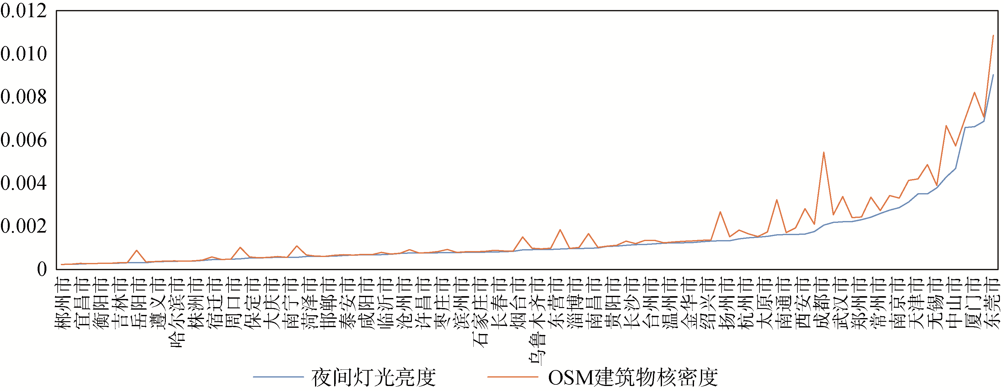
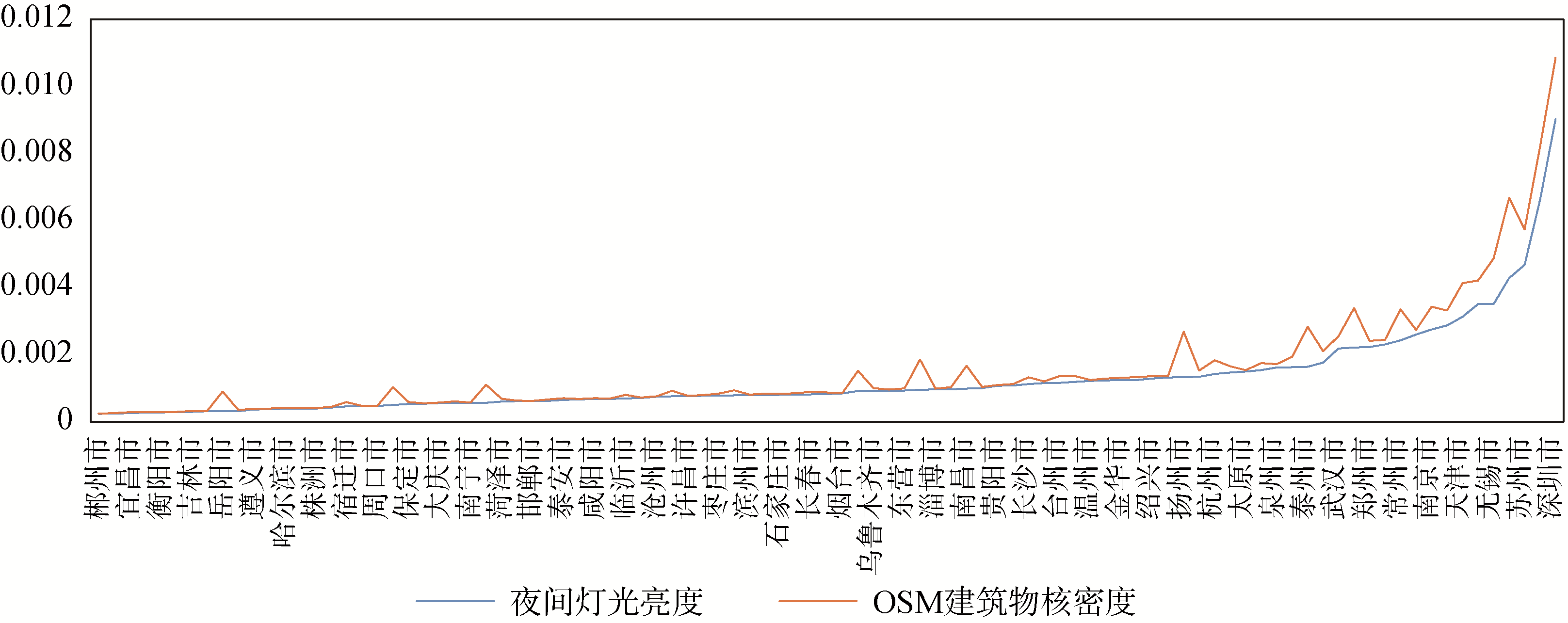
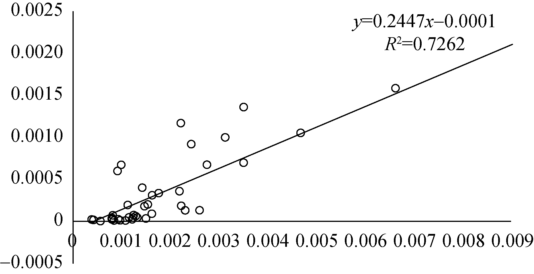
[Objective] This paper aims to address data integrity issues facing the OpenStreetMap (OSM) datasets. [Methods] First, we retrieved the remote censor images of night-lighting brightness as an indicator for cities with strong comprehensive competitiveness. Then, we studied the correlation between night-lighting brightness and OSM completeness, which identified the distribution patterns of high quality data. [Results] We established a regression model for OSM building density and night-lighting brightness. The correlation coefficient was 0.8522. We also found that 84.2% of Chinese cities in our study had building densities closed to the predicted values (the discrepancy was less than 0.5%). The building densities in the other cities were 2% to 7% lower than the expected values. [Limitations] More research is needed to evaluate the performance of this model with other cities. [Conclusions] The remote sensing images help us assess quality of OSM data, which also identifies the “ghost or empty cities”.
刘菲,成晓强,吴华意. 基于夜间灯光亮度的OpenStreetMap数据完整性检验 *[J]. 数据分析与知识发现, 2019, 3(9): 36-44.
Fei Liu,Xiaoqiang Cheng,Huayi Wu. Assessing Data Integrity of OpenStreetMap Based on Night Lights. Data Analysis and Knowledge Discovery, 2019, 3(9): 36-44.
Rambaldi G, Kyem P A K, McCall M , et al. Participatory Spatial Information Management and Communication in Developing Countries[J]. The Electronic Journal of Information Systems in Developing Countries, 2006,25(1):1-9.
[2]
Goodchild M F . Citizens as Sensors: The World of Volunteered Geography[J]. GeoJournal, 2007,69(4):211-221.
doi: 10.1007/s10708-007-9111-y
[3]
Goodchild M F . Geographic Information Systems and Science: Today and Tomorrow[J]. Annals of GIS, 2009,15(1):3-9.
[4]
Fritz S, McCallum I, Schill C , et al. Geo-Wiki. Org: The Use of Crowdsourcing to Improve Global Land Cover[J]. Remote Sensing, 2009,1(3):345-354.
[5]
Goodchild M F, Glennon J A . Crowdsourcing Geographic Information for Disaster Response: A Research Frontier[J]. International Journal of Digital Earth, 2010,3(3):231-241.
( Luo Luchang, Liu Bo, Liu Xuechao . Data Quality Assessment and Application Analysis for OpenStreetMap Road Network[J]. Jiangxi Science, 2017,35(1):151-157.)
[7]
Gröchenig S, Brunauer R, Rehrl K . Estimating Completeness of VGI Datasets by Analyzing Community Activity over Time Periods[A]// Huerta J, Schade S, Granell C. Connecting a Digital Europe Through Location and Place[M]. Springer, 2014: 3-18.
( Ma Chao, Sun Qun, Xu Qing . An Approach for Volunteered Geographic Information Quality Evaluation Based on Reference Data[J]. Geomatics & Spatial Information Technology, 2017,40(3):1-5.)
[9]
朱富晓, 王艳慧 . 多层次多粒度 OSM 路网目标数据质量综合评估方法研究[J]. 地球信息科学学报, 2017,19(11):1422-1432.
[9]
( Zhu Fuxiao, Wang Yanhui . On the Comprehensive Evaluation of the Data Quality for OSM Road Network from the Perspectives of Multi-level and Multi-granularity[J]. Journal of Geo-Information Science, 2017,19(11):1422-1432.)
( Wang Ming, Li Qingquan, Hu Qingwu , et al. Quality Analysis on Crowd Sourcing Geographic Data with Open Street Map Data[J]. Geomatics and Information Science of Wuhan University, 2013,38(12):1490-1494.)
[11]
Ludwig I, Voss A, Krause-Traudes M . A Comparison of the Street Networks of Navteq and OSM in Germany[A]// Geertman S, Reinhardt W, Toppen F. Advancing Geoinformation Science for a Changing World[M]. Springer, 2011: 65-84.
[12]
Haklay M . How Good is Volunteered Geographical Information? A Comparative Study of OpenStreetMap and Ordnance Survey Datasets[J]. Environment and Planning B: Planning and Design, 2010,37(4):682-703.
doi: 10.1016/j.amjcard.2004.02.006
[13]
Kounadi O . Assessing the Quality of OpenStreetMap Data [D]. London: University College of London Department of Civil, Environmental and Geomatic Engineering. 2009.
[14]
Zheng S, Zheng J . Assessing the Completeness and Positional Accuracy of OpenStreetMap in China[A]// Bandrova T, Konecny M, Zlatanova S. Thematic Cartography for the Society[M]. Springer, 2014: 171-189.
( Li Deren, Li Xi . Applications of Night-time Light Remote Sensing in Evaluating of Socioeconomic Development[J]. Journal of Macro-quality Research, 2015,3(4):1-8.)
[16]
Elvidge C D, Tuttle B T, Sutton P C , et al. Global Distribution and Density of Constructed Impervious Surfaces[J]. Sensors, 2007,7(9):1962-1979.
( Zheng Hui, Zeng Yan, Wang Yong , et al. Urban Building Density Estimation Based on the VIIRS Night-time Satellite Data—A Case of Nanjing[J]. Science Technology and Engineering, 2014,14(18):68-75.)
[18]
Zhou Q . Exploring the Relationship Between Density and Completeness of Urban Building Data in OpenStreetMap for Quality Estimation[J]. International Journal of Geographical Information Science, 2018,32(2):257-281.
[19]
Silverman B W . Density Estimation for Statistics and Data Analysis[M]. New York: Routledge, 1986.
[20]
Jalobeanu A, Blanc-Féraud L, Zerubia J . Satellite Image Deblurring Using Complex Wavelet Packets[J]. International Journal of Computer Vision, 2003,51(3):205-217.
doi: 10.1023/A:1021801918603
[21]
Jalobeanu A, Zerubia J, Blanc-Féraud L. Bayesian Estimation of Blur and Noise in Remote Sensing Imaging[A]// Campisi P, Egiazarian K. Blind Image Deconvolution: Theory and Applications[M]. CRC Press, 2007: 239-275.
[22]
Zhang Y, Man Y . Satellite Image Adaptive Restoration Using Periodic Plus Smooth Image Decomposition and Complex Wavelet Packet Transforms[J]. Tsinghua Science and Technology, 2012,17(3):337-343.
( Li Yaping, Cai Zhongliang, Xie Caiyun , et al. A Case Study in Usability Evaluation Method of Open Geospatial Data[J]. Journal of Geomatics, 2017,42(1):83-87.)